Wynyard Quarter, Auckland Waterfront, NZ

DSC04253

The Wynyard Quarter’s Karanga Plaza and Silo Park have in a short time become two of Auckland’s most praised and loved public spaces. As Auckland vies for the lofty title of being the “Most Livable City in the World” by 2040, the redevelopment and reimagining of the city’s waterfront is a key strategy to achieve this goal.

Placemaking –  Lighter, Quicker, Cheaper 

The Lighter, Quicker, Cheaper approach to placemeaking, as advocated by the Project for Public Space (PPS.org), is visable throughout the waterfront’s newly reinterpreted  spaces. Approaching Karanga Plaza, distinctively patterned ground markings, street furniture, and planters to separate pedestrian space from a unfriendly surface parking lot. A simple, cost effective design to soften an otherwise hard edge and create visual interest.

Carpark

In keeping with the active industrial use of the waterfront, shipping containers are used for temporary bus shelters, bathrooms, retail stores, sales offices, or as a free library (as below).

container2

Moveable street furniture allows for flexibility of use and encourages passive recreation and consumption.

DSC04290$$

Polished chrome sculptures of ships air ventilation funnels and speaking tubes  are re-interpreted as urban furniture. This ‘Sound of the Sea’ installation projects the echos of crashing waves beneath the boardwalk, as well as offering seating and interactive street art. Retaining weathered concrete ground cover, rusting tram lines, and adaptive use of shipping warehouses adds a thread on continuity between the industrial / maritime activity and the waterfronts new residential and commercial uses.

DSC04258

DSC04257

DSC04264$$      DSC04268$$

Also noticeable is a strong emphasis on placemaking for children and families. Maritime themed street art and playful seating attract younger age groups and again links new uses and users to existing waterfront activity.

DSC04289

Creative reuse of corrugated warehouses as retail units and restaurants preserve the character of the waterfront and attract high levels of activity.

Silo Park

DSC04272

At Silo Park, maritime themed markers separate conflict areas between pedestrian spaces and traffic calmed vehicle spaces.

DSC04273

The Wind Tree

DSC04283

DSC04275

DSC04274

Event programming for Silo Park includes an outdoor cinema (projecting movies against the disused concrete silos), weekend craft markets, and live music and entertainment. As the above photos (from a chilly day in October) suggest, he variety of spaces, functions and moods created by both temporary and permanent placemaking attracts a wide variety of users.

More here:

http://www.silopark.co.nz/

Posted in Uncategorized | Leave a comment

ph.bikebox

Hey, Bicycle Bill

In 1971, while the anti-highway movement was gathering real pace, another watershed moment for bicycle and pedestrian transportation took place. Led by another Republican legislator Don Stathos, Governor McCall backed the passage of Oregon House Bill 1700, commonly known as the “Bicycle Bill”. This legislation required cities in Oregon to spend a minimum of 1% of funds received from the Oregon State Highway Fund on bicycle and pedestrian infrastructure when constructing, repairing or relocating a road.

The Bill led to the creation of the present day Oregon Bicycle and Pedestrian Advisory Committee, a governor appointed committee that advise the Oregon DOT. Subsequently, the development of Portland’s first Bicycle Plan in 1973 by a residents task force, and the Portland Office of Transportation’s Bicycle Program, put active transportation firmly on the City of Portland’s agenda.

However, it would be another 20 years before the Bill’s provisions would be implemented in earnest. Unfortunately, as city and state leadership changed in subsequent years, the necessary political will to enforce the Bill dwindled and it’s numerous exemptions and ambiguities were often exploited. While a primitive bicycle network did emerge across the city, it fell some way short of the ambitious 190 miles of bikeways which the 1973 Bicycle Plan called for.  In fact, by 1992 just 83 miles of bikeways existed in the city.

Despite the Reagan era of cheap gas prices and increased car ownership, Portland did experience modest growth in bicycle numbers between the mid 1970’s and early 1990’s. According to PDXcityclub.org, between 1975 and 1992, the number of bicycle riders crossing the Hawthorne Bridge increased from 200 to 1,400 per day.

The Continuing Story of of Bicycle Bill

Well organized grassroots activist and advocacy groups have been a feature of the sustainable transportation agenda in Oregon (see pt. 1). However, the formation of the Bicycle Transport Alliance in 1990 would prove to be another watershed moment for the bicycle movement in the city. Frustrated with how the City ignored the needs of it’s bicyclists, the BTA brought together disparate activists and passionate bicyclists. Founded by Rex Burkholder (amongst others) they had early success persuading TriMet, (the region’s transit provider), to install bike racks on all it’s buses. The BTA were just getting started.

From it’s foundation the BTA recognized the unfulfilled potential of the Stathos’ Bicycle Bill. They repeatedly challenged city and state leadership on the issue, arguing the need and demand for safe bicycle facilities on the city’s main streets, as well as the willful neglect of the Bicycle Bill’s legislation. But Transportation Commissioner Earl Blumenauer and Portland’s Mayor Vera Katz refused to offer any serious support. It became clear to Burkholder that the only way to resolve conflicting interpretations of the Bill would be to take it to the courtsThe multi-million dollar proposal for the construction of the Rose Bowl Stadium in downtown Portland provided the perfect opportunity for the BTA to make its case.

The project entailed $34 million of public funds to reconstruct roads and improve accessibility to the facility. Again, the BTA demanded pedestrian and bicycle facilities to be included and again, the City offered only token gestures. The BTA vs. the City of Portland ensued. It took 10 volunteer lawyers two years to convince the court (and appeals court) that state and local governments must provide bicycle and pedestrian facilities as part of all road projects – as Don Stathos had intended way back in 1971. In a landmark decision,  the judge ruled in favor of the BTA.

Finally the Bicycle Bill had gotten some serious legal teeth and the BTA major clout in regional transportation circles. The BTA has since grown into a 5,000+ strong member organization, and Burkholder has since been elected to the Metro Council and formerly served as Chair of the region’s Joint Policy Advisory Committee on Transportation. Importantly, the BTA also won over the support of Blumenauer, who would oversee a wave of bicycle facility construction and the start of Portland’s bicycle renaissance.

Build it and they will come…. Bicycling in Portland.

Blumenauer hired a young woman named Mia Birk to manage the City’s Bike Program, giving her a strong mandate and his political support. Birk embarked upon a major program to engage cyclists and potential cyclists in a dialogue about ways to increase ridership. Working with activists, advocacy groups and communities, she set about designing bottom-up policy which identified and resolved bicyclists needs and concerns.

Overwhelmingly, improvements to the city’s bridges and supporting road networks were identified as the key infrastructure requirements. Providing bicyclists with safe connections between the city’s pedestrian and bicycle-friendly neighborhoods and emerging business districts on the east side of the Willamette River with its amenity rich downtown on the west side would be critical.  The City adopted a “build it and they will come” approach by investing in improved bridge facility quality and access.

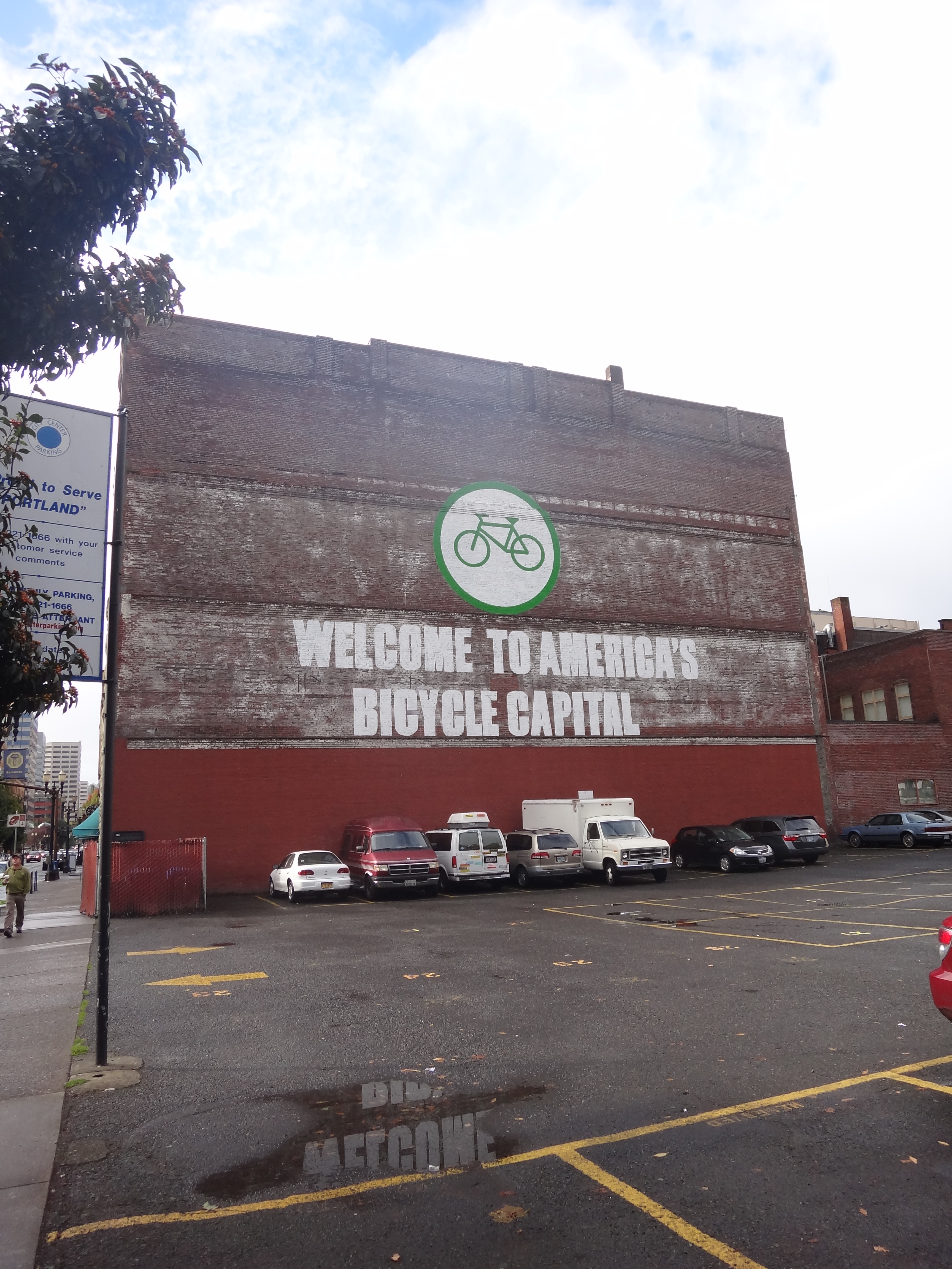
Daily bicycle trips over the critical Hawthorne and Broadway bridges increased steadily as infrastructure improvements took effect. Sidewalks were widened, separated bike lanes were built over bridges and their approaches, and conflict zones were marked. Most importantly, bicyclist numbers grew. In fact, by 1995 Portland was named the most bicycle friendly city in the US by Bicycling Magazine – who recognized the extent of the City’s efforts.

In the short time between of the BTA’s Bicycle Bill victory in 1992 and the release of the Portland Bike Plan in 1996, the city had added over 50 miles of bikeways in some of the most strategically important areas. It had developed bike lanes, bike boulevards, and off street paths, over 1,400 public bicycle racks were installed, and Bike Central stations were built providing showers, changing facilities, and long-term bicycle storage. Bicycle transportation was gaining momentum quickly, and more was to come.

The Bicycle Master Plan 1996

After a two and half year preparation, including rigorous public consultation, the Bicycle Master Plan was released in 1996. Aiming to making the bicycle an integral part of daily life in Portland, it called for approximately 445 miles to be added to the existing system to create an ambitious 630 mile network of bikeways throughout the city over the next 20 years.

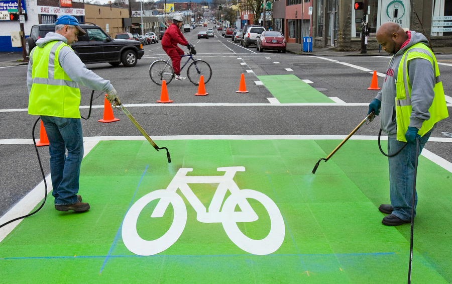
This network would safely facilitate bicycling to commercial districts, employment centers, transit stations, and recreational destinations. Citywide parking facilities and end of trip facilities would be improved, as would bicycle to transit links. Education and promotion of the benefits of cycling would be prioritized, and importantly best practice design and engineering guidelines were provided. Portland borrowed heavily from Dutch and Danish tradition, New Urbanist ideas and from bicycle friendly college towns such as Davis, CA. Road diets were implemented on 4-lane roads with excess capacity, and safe, separated lanes were introduced where traffic moved at dangerous speeds. In addition, Bike Boulevards were introduced to traffic calmed residential areas, providing quick thoroughfares for bicyclists.

By the time Birk left her position in 1999, Portland had well in excess of 200 miles of bikeways and a rapidly increasing modal share. Although the 1996 plan has so far fallen short of its objective in terms of bikeway construction, the city has experienced an impressive rise in bike ridership. Between 1996 and 2010 (when the plan was revised) Portland extended its bikeway network to 300 miles – a gain of approximately 115 miles. 

Portland experienced a 65% increase in cycling numbers between 1990 to 2010. According to the Census Bureau’s annual American Community Survey, between 1990 and 2008, the number of bicycle commuters in Portland rose by approximately 5%  – from 1.2% to 6.0%. The rise was undoubtedly helped by a surge in gas prices over the same period, but compared to other West coast cities, Portland’s gains are impressive.

How much?

However, equally impressive is how little building a city wide bicycle infrastructure has cost the taxpayer. According to Birk, Portland has, for the cost of one mile of freeway – about $50 million – built its entire bikeways network.

Under the auspice of pro-bicycle Mayor Charlie Hales and current Bicycle Coordinator Roger Geller, rising bicycle numbers and cost efficient infrastructure investment looks set to continue. The 2030 Bicycle Plan, adopted in 2010, doesn’t shy away from of its predecessors ambitions, calling for the network of planned bikeways to be increased from 630 to 960 miles. It aims for a modal share of 25%, and to compete with the top European bicycling cities.

While Portland still has a long way to go in terms of becoming a bicycle city in global terms, in the mean time Portland residents can enjoy less congestion, improved air quality, and a healthier, more livable city….and the title of America’s Bicycle Capital.

Some other things to consider..

  • While most American cities have seen their residents drive farther and spend more time in traffic – Portland’s vehicles miles travelled per person peaked in the mid- 1990’s.
  • Compared to other large cities, Portlanders on average drive 20% less – which produces annual savings on cars and gasoline expenses of $1.1 billion – which in turn, has a huge multiplier effect on the regional economy (at least 73% of money spent on gasoline would be exported). 
  • In 2006, the City commissioned a study that estimated that bike-related businesses were generating $63 million a year – a sign of the industry’s increasing importance. More recently, The Oregonian has reported  estimates that recreational bicycle travel accounts for $400 million of Oregon’s annual $9 billion tourism industry.
  • Mia Birk is now the president of Alta Planning and Design and is still heavily involved in improving sustainable transportation in Portland. It’s sister company, Alta Bike Share, designs and manages bicycle share systems.  It has brought bike shares to Chicago, San Francisco, Washington D.C. and Melbourne.  In 2014 Alta plans to launch a bike share in Portland.
Posted on by qimby | 2 Comments

How Portland became America’s Bicycle Capital Pt.1


PDX

Portland’s reputation as the US’s bicycle capital is well publicized. The ‘how’ and the  ‘why’ it became so is less well known. As you might expect, it’s not quite as simple as painting some bike lanes at the side of the road. In fact, the explosion in popularity in bicycling in Portland over the past decades can be traced back to series of landmark decisions made in the 1970’s which had radical implications for all transportation modes in the city. In particular, a period of environmentally innovative leadership at state level, and the emergence of a grass-roots anti-highway movement in the late 60’s became instrumental agents of change towards a bicycle and pedestrian friendly Portland.

Roads? Where we’re going we don’t (just) need roads..

The late 1960’s and early 1970’s was a period of radical policy and political reform in Oregon. In particular, the emergence of progressive new land use and environmental controls which garnered Oregon national and international attention. Under the Governorship of Tom McCall (1967 – 1975) the state embraced a new set of standards in environmental stewardship and foresighted policy concerning the protection of it’s beaches, waterways, and forests. Oregon’s land use planning system was dramatically revised, sustainable transportation methods were encouraged, and the framework for urban growth boundaries were established.

Against a backdrop of a decade of soaring federal highway expenditure, sprawling subdivisions, and increasing environmental concern, McCall campaigned on a strong environmental platform. He succeeded in capturing the imagination of Oregonians disillusioned by the treatment of their natural resources and increasingly automobile dominated landscapes.

By the late 1960’s this rampant freeway construction was met with considerable backlash from well-organized community groups. Declining US oil production and exponentially rising gas prices, brought a sharp focus on the issue and created an appetite for alternative transportation solutions. Early anti-highway movements, with the support of McCall, succeeded in closing down an inner city expressway and its conversion into a public park. Similarly, the planned construction of a 13-story parkade on the site of what is now Pioneer Square was halted. Both are now much loved public spaces in the city.

However, it was the proposed Mount Hood freeway that resulted in the largest, region-wide, opposition. The 8 km freeway was planned to run through downtown Portland to the eastern suburbs, effectively taking out 1% of the city’s housing and destroying large numbers of businesses.As freeway construction progressed, citizens caution turned to disapproval and community opposition galvanized. The provisions of the newly enacted National Environmental Protection Act gave community groups a legal foothold and caused significant delays in construction as Environmental Impact Assessments were demanded and subsequently carried out.

Concerted pressure on political figures resulted an important shift in city leadership (detailed here), which led to the City, County and State withdrawing their support for the freeway. In late 1974 Governor McCall notified the Secretary of Transportation that he would remove the most controversial parts of the Mt. Hood Freeway but intended to keep the assigned federal funding for other transportation projects – most notably LRT.

The defeat of the Mt. Hood Highway proved to be a landmark decision for Portland. Most significantly, it marked the beginning of committed efforts to integrate land use and transportation planning in the US. It has allowed Portland to invest in a regional LRT  and resulted in a revival of inner city neighborhoods and increased livability in Portland.

It paved the way (no pun intended) for the implementation of an urban growth boundary in the late 1970’s and for continued investment in bicycle and pedestrian infrastructure. In turn this has significantly mitigated the effects of suburban sprawl and contributed to a drastic reduction in the amount of vehicle miles travelled per person. Portlander’s drive 20% less compared to other major metropolitan areas!

Although Portland hasn’t been able to completely avoid the “sagebrush subdivisions”, and “ravenous rampages of suburbia” which McCall and the anti-highway community groups rallied against, the critical decisions made in the 1970’s to prioritize the type of urban form Portlander’s preferred (and then design transportation systems to support them), has spared them from the woes of unfettered suburban sprawl.

Posted in Sustainable transport | Tagged , , , , , , , , | 1 Comment

Image

The quality of the urban fabric directly impacts the quality of our daily lives. This blog finds nothing more unattractive in an urban landscape than a blank wall or building side.

Facilitating pedestrian mobility is a priority for any city with serious sustainability objectives. To that end, one of the keys to achieving walkable streets is to provide an interesting and engaging pedestrian experience.

Replacing wasted space and uninteresting pedestrian environments with colourful, positive messages, Dublin artist Maser does a good job fixing this problem!

 Image

Image

Image

imageimage

Public space is nearly always more important than the collective merits of individual buildings.  But when the value in these spaces is overlooked, in this case whether its a boring, blank wall, an uninviting pedestrian environment, or a unactive gable end of a building – all of us pedestrian, as users of the space, are impoverished by our surroundings.

The great blight of dullness as J. Jacobs might say.

<blockquote class=”twitter-tweet” lang=”en”><p>Great urban design seeks to essentially ban blank walls. It can never be fully accomplished, but the effort is key to <a href=”https://twitter.com/search?q=%23walkable&amp;src=hash”>#walkable</a&gt; streets.</p>&mdash; Brent Toderian (@BrentToderian) <a href=”https://twitter.com/BrentToderian/statuses/436316805124997120″>February 20, 2014</a></blockquote>
<script async src=”//platform.twitter.com/widgets.js” charset=”utf-8″></script>

Posted on by qimby | Leave a comment

DSC_4290 DSC_4277

In February 2011, a 6.3 magnitude earthquake devastated Christchurch, New Zealand causing severe and widespread damage to the city center and suburbs. Hundreds of historic buildings, landmarks and streets were leveled. Large parts of the city center’s core business, residential and historic areas were designated inaccessible “red zones”. Everyday life in the city center came to an almost complete halt.

A group of local property owners and developers acted swiftly to revitalize the city. The Re:Start project, led by Buchan Group, Leighs Construction, and Rough and Milne Landscape Architects, constructed a temporary, pedestrian retail prescient in the heart of Christchurch  using shipping containers and astute design.

layout-plan
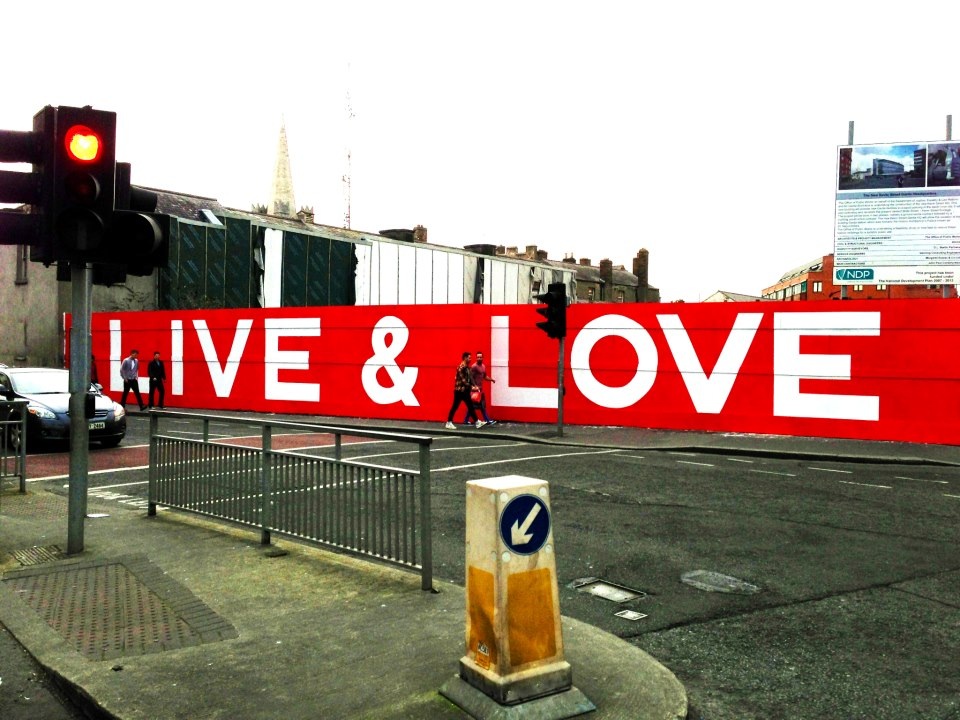
The project became seen as a first step in the city’s rebuild, seeking to re-establish business and retail around the Cashel Street area anchored by the remaining department store Ballintynes.

CSC_4285 CSC_4284

Over the course of a 2 month construction, 61 shipping containers were transformed into 27 retail premises and a reusable place-making resource for the city. The shipping containers were arranged, either single or multi level, into U-shaped lanes, which flank a pedestrian thoroughfare linking Columbo Street with the Bridge of Remembrance. A highly modular design and bright, vibrant color pallet added further visual interest creating an inviting, comfortable, and memorable public space.

CSC_4287 CSC_4291

 Re:Start and Cashel Steet was reopened in October 2011 and was scheduled to be dismantled after 6 months. As of Summer 2013, it still stands. In fact, according to a report in local newspaper The Press on June 4th 2013, the area is now busier than before the earthquakes. Foot traffic counts in the Cashel St. mall were reported to be up by 23% on counts made in the area in 2008. The increasing numbers of people that shop, dine and spend time there everyday indicate Re:Starts success. 

DSC_4278

Posted on by qimby | Leave a comment

Sprawl Calgary

This blog in going to kick off with an examination of an archetypal Canadian sprawl city – Calgary Alberta. It will start by looking at the main development phases the city has undergone, the resulting urban morphology and their place within a wider economic context. Later, I will blog about modern day sprawl in the city and the efforts made by the municipal authorities to achieve a more sustainable pattern of growth. This will all trickle online over the coming weeks and months. Hopefully it bring together much of what has been written on the subject previously with an analysis of current policy and media reaction. All condensed and distilled into a concise series of blog posts! Here goes.. 

Posted in Uncategorized | Leave a comment

Jan Gehl says…

“A good city is like a good party…”

Posted in Quote | Tagged , | Leave a comment